
Land Surveying services provide a clear picture of a site to help our clients understand its possibilities and potential obstacles. A|I|DATA provides detailed surveys to inform clients on the best path forward to project completion. Our surveying services play an important role in all phases of your project. From the preliminary design phase to your project closeout, our team is ready to support you with the critical data necessary to complete your project with confidence.
The A|I|DATA land surveying team provides a spectrum of services to tackle your project needs. We know that every site has its unique challenges. That is why A|I|DATA surveyors are fully stocked with the latest equipment and technology to provide accurate and reliable data to every client. From records research to field data collection, office processing, and mapped presentations we offer a valuable picture of features above and below ground.
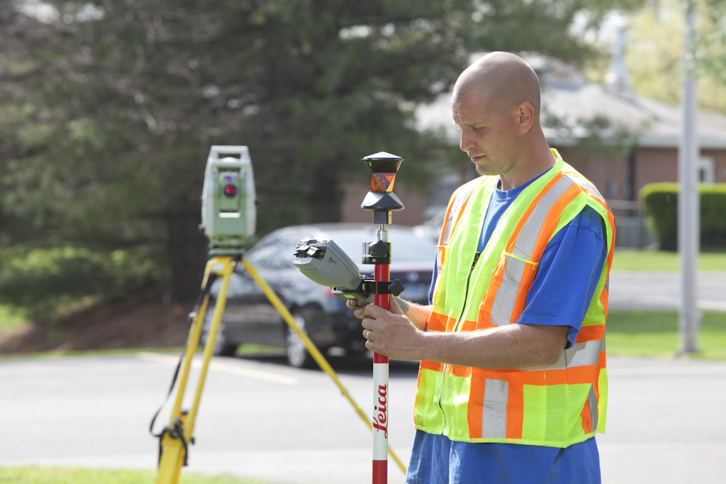
We are staffed with experienced Professional Land Surveyors to provide quality surveys for our private and public sector clients. A|I|DATA takes pride in delivering an accurate and reliable service by utilizing a combination of conventional methods with modern technology such as Robotic Total Stations, GNSS/GPS Receivers, and Civil 3D and MicroStation software.
Our surveys adhere to the common practices and standards of professional care within their relevant jurisdictions. A|I|DATA has licensed Professional Land Surveyors in Delaware, Maryland, New Jersey, Washington, DC, and West Virginia.
Control Surveys
The field data collected by our survey crews is vital to the process of every project. The field surveyors are usually the first to set foot on a site (and often the last to leave). The information gathered by these surveyors sets the foundation for each project. Control Surveys establish the horizontal and vertical reference system for project activities. The survey control is recovered, established, and verified using the relevant standards and methods.
Topographic Surveys
Our topographic survey provides a clear picture of a project to help our clients understand the potential of a site as well as any of its obstacles. A|I|DATA uses detailed surveys to inform our clients on the best path forward for project completion.
In combination with our in-house SUE services, A|I|DATA surveyors can provide a detailed map of above-ground features as well as underground utilities. A topographic survey from A|I|DATA offers the convenience of a one-stop-shop for accurate SUE and survey data.
Boundary Surveys
A boundary survey is an essential service used to give clients a clear understanding of the limits of their property lines and the locations of any easements that may affect them. A|I|DATA has licensed Professional Land Surveyors with expertise in recovering and reestablishing your property boundaries. This is important for any project involving land development, construction, or transportation. Our experienced technicians initiate the project by conducting in-depth deed/records research and generating a detailed mosaic of the property’s legal description. Thorough field surveys are conducted to gather property line evidence. The field evidence is then processed and analyzed by one of our licensed Professional Land Surveyors to determine property boundaries, rights of way, and easement locations.
ALTA/NSPS Land Title Surveys
ALTA surveys are one of the most detailed and comprehensive property survey services. ALTA surveys are beneficial for commercial real estate transactions, land purchases, and property acquisition for future development. An ALTA survey captures your specific needs for title insurance matters.
These surveys are in compliance with the minimum standard detail requirements set forth by American Land Title Association (ALTA) and the National Society of Professional Surveyors (NSPS). Our licensed professionals have experience working with attorneys, lenders, and title companies to provide a visual representation of any title commitment item selected from the ALTA/NSPS Table A item checklist. We understand that these surveys are heavily relied on by our clients. Our ALTA surveys help put your mind at ease by incorporating our high detailed planimetric and boundary surveys along with our in-house SUE utility locations when requested.
As-Built Surveys
Under the responsible charge of a duly licensed Land Surveyor, A|I|DATA conducts As-Built Surveys. These surveys are also known as As-Constructed or Record Surveys. An As-Built Survey is used to verify the horizontal and/or vertical locations of known improvements. It comprises field data and an analysis of the record information compared to the field evidence. Clients are made aware of any significant discrepancies from the record information.
Additional Services
- Easement plats
- Right-of-way plats
- Condominium and subdivision plats
- Lot line adjustments
- Metes and bounds description
- GIS field maps
- Planimetric surveys